National Weather Service: heavy rainfall likely tonight; frontal system may produce storms through Friday
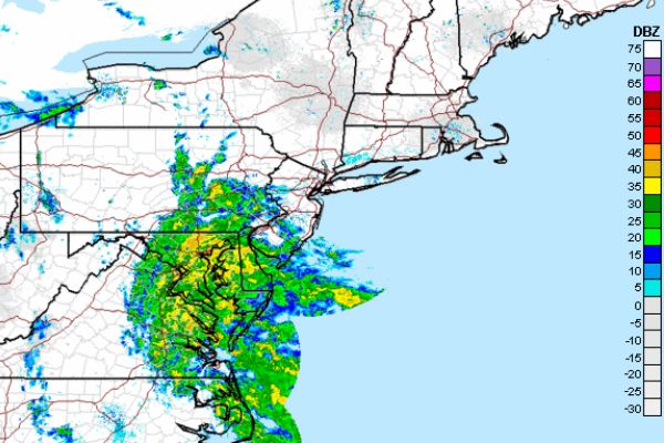
NWS Radar Mosaic
From the National Weather Service Forecast Office in New York:
Western Passaic-Eastern Passaic-Hudson-Western Bergen-Eastern Bergen-
Western Essex-Eastern Essex-Western Union-Eastern Union-Rockland-
Northern Westchester-Southern Westchester-New York (Manhattan)-Bronx-
Richmond (Staten Island)-Northern Queens-
352 AM EDT Sat Jul 21 2018
This Hazardous Weather Outlook is for northeast New Jersey and
southeast New York.
.DAY ONE…Today and Tonight.
There is potential for locally heavy rainfall this evening through
tonight that could lead to localized urban flash flooding.
.DAYS TWO THROUGH SEVEN…Sunday through Friday.
A nearly stationary frontal system could produce showers and
thunderstorms capable of causing flash flooding through much of the
week.
Long Island Sound East of New Haven CT/Port Jefferson NY-
Long Island Sound West of New Haven CT/Port Jefferson NY-
New York Harbor-Peconic and Gardiners Bays-
South Shore Bays from Jones Inlet through Shinnecock Bay-
Fire Island Inlet NY to Moriches Inlet NY out 20 nm-
Sandy Hook NJ to Fire Island Inlet NY out 20 nm-
352 AM EDT Sat Jul 21 2018
…GALE WARNING IN EFFECT FROM 6 PM THIS EVENING TO 6 AM EDT
SUNDAY…
This Hazardous Weather Outlook is for Atlantic coastal waters.
.DAY ONE…Today and Tonight.
Please listen to NOAA Weather Radio or go to weather.gov on the
Internet for more information about the following hazards.
Gale Warning.
.DAYS TWO THROUGH SEVEN…Sunday through Friday.
No hazardous weather is expected at this time.
$$
Moriches Inlet NY to Montauk Point NY out 20 nm-
352 AM EDT Sat Jul 21 2018
…GALE WARNING IN EFFECT FROM 6 PM THIS EVENING TO 11 AM EDT
SUNDAY…
This Hazardous Weather Outlook is for Atlantic coastal waters.
.DAY ONE…Today and Tonight.
Please listen to NOAA Weather Radio or go to weather.gov on the
Internet for more information about the following hazards.
Gale Warning.
.DAYS TWO THROUGH SEVEN…Sunday through Friday.
Please listen to NOAA Weather Radio or go to weather.gov on the
Internet for more information about the following hazards.
Gale Warning.
This Hazardous Weather Outlook provides a summary of potential
widespread hazardous weather events that may reach NWS warning
criteria. Most long fused NWS watches…warnings and advisories in
effect are highlighted.
Please refer to the latest NWS forecasts for weather not meeting NWS
warning criteria.


