

Winter Weather Advisory: Snow starts Thursday night with 3 to 6 inches forecast
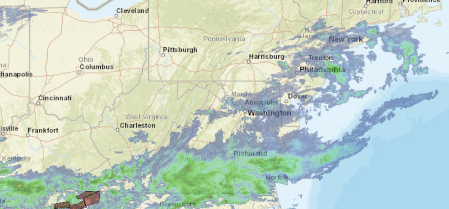
National Weather Service national radar mosaic at 1:55 p.m.
URGENT – WINTER WEATHER MESSAGE
National Weather Service New York NY
Orange-Putnam-Rockland-Northern Westchester-Southern Westchester-
1023 AM EST Thu Feb 24 2022
…WINTER WEATHER ADVISORY REMAINS IN EFFECT FROM 10 PM THIS EVENING TO 1 PM EST FRIDAY…
* WHAT…Mixed precipitation expected. Total snow accumulations of 3 to 6 inches and ice accumulations of around one tenth of an inch.
* WHERE…Orange, Rockland, Putnam, Southern Westchester and Northern Westchester Counties.
* WHEN…From 10 PM this evening to 1 PM EST Friday.
* IMPACTS…Plan on slippery road conditions. The hazardous conditions could impact the morning commute.
PRECAUTIONARY/PREPAREDNESS ACTIONS…
Slow down and use caution while traveling.
Check local Department of Transportation information services for the latest road conditions.
Hazardous Weather Outlook: A wintry mix of snow and sleet is expected to develop Thursday night into early Friday morning. The precip then changes to freezing rain and rain after daybreak Friday morning. Impacts to the Friday morning commute are possible, especially away from the immediate coast where the wintry mix hangs on longest before a changeover to plain rain.
Storm-related announcements: