As Isaias approaches, National Weather Service issues tropical storm warning; police put out advisories
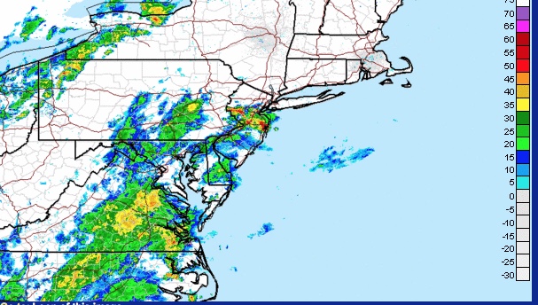
The National Weather Service has issued a tropical storm warning starting Tuesday night for Westchester and the rest of the Tri-State area as Tropical Storm Isaias approaches from the south. The full bulletin is below. The Pelham and Pelham Manor police departments also put out advisories, while Metro North will run a Saturday schedule on Tuesday and warns of disruptions after 3 p.m.
Pelham Manor Police: “With the pending arrival of Tropical Storm Isaias, we have already assigned an officer to liaise directly with Con Ed as of tomorrow morning.”
Pelham Police: “Tropical Storm Isaias will impact the entire Tri-State area Tuesday night into Wednesday. The main threat with this system will be local flooding and strong winds. The likely impact of this storm may down tree limbs, trees, power lines and/or cause structural damage. Power outages are also possible and travel could be difficult for high profile vehicles.”
“Residents are urged to contact Con-Edison to report power outages or service problems by calling 1-800-75-CONED or online at www.coned.com. You can also view service restoration information and an outage map. Con Edison customers can sign up for text notifications at conEd.com/text or by texting to REG to OUTAGE (688243) and follow the prompts. You will need to enter your Con Edison account number to complete the registration process. Once you’ve registered, you will not need your account number to report or check the status of a power problem.”
“Residents should also take the following precautions:
- Treat all downed utility lines as energized.
- Treat all intersections with an inoperable traffic signal as a four way stop intersection.
- Secure any property or objects outside your home or bring them inside to best limit damage or potential injuries.
- Please contact the Pelham Police Department at (914) 738-2000 if you need any assistance.”
From the National Weather Service:
...TROPICAL STORM WARNING REMAINS IN EFFECT...

* LOCATIONS AFFECTED
    - New Rochelle
    - White Plains
    - Hastings on Hudson

* WIND
    - LATEST LOCAL FORECAST: Equivalent Tropical Storm force wind
        - Peak Wind Forecast: 40-50 mph with gusts to 65 mph
        - Window for Tropical Storm force winds: Tuesday afternoon
          until early Wednesday morning

    - THREAT TO LIFE AND PROPERTY THAT INCLUDES TYPICAL FORECAST
      UNCERTAINTY IN TRACK, SIZE AND INTENSITY: Potential for wind 58
      to 73 mph
        - The wind threat has remained nearly steady from the
          previous assessment.
        - PLAN: Plan for dangerous wind of equivalent strong tropical
          storm force.
        - PREPARE: Remaining efforts to protect life and property
          should be completed as soon as possible. Prepare for
          significant wind damage.
        - ACT: Move to safe shelter before the wind becomes hazardous.

    - POTENTIAL IMPACTS: Significant
        - Some damage to roofing and siding materials, along with
          damage to porches, awnings, carports, and sheds. A few
          buildings experiencing window, door, and garage door
          failures. Mobile homes damaged, especially if unanchored.
          Unsecured lightweight objects become dangerous projectiles.
        - Several large trees snapped or uprooted, but with greater
          numbers in places where trees are shallow rooted. Several
          fences and roadway signs blown over.
        - Some roads impassable from large debris, and more within
          urban or heavily wooded places. A few bridges, causeways,
          and access routes impassable.
        - Scattered power and communications outages, but more
          prevalent in areas with above ground lines.

* STORM SURGE
    - LATEST LOCAL FORECAST: Localized storm surge possible
        - Peak Storm Surge Inundation: The potential for 1-3 feet
          above ground somewhere within surge prone areas
        - Window of concern: Tuesday afternoon until early Wednesday
          morning

    - THREAT TO LIFE AND PROPERTY THAT INCLUDES TYPICAL FORECAST
      UNCERTAINTY IN TRACK, SIZE AND INTENSITY: Potential for storm
      surge flooding greater than 1 foot above ground
        - The storm surge threat has remained nearly steady from the
          previous assessment.
        - PLAN: Plan for storm surge flooding greater than 1 foot
          above ground.
        - PREPARE: Complete preparations for storm surge flooding,
          especially in low-lying vulnerable areas, before conditions
          become unsafe.
        - ACT: Leave immediately if evacuation orders are given for
          your area.

    - POTENTIAL IMPACTS: Limited
        - Localized inundation with storm surge flooding mainly along
          immediate shorelines and in low lying spots, or in areas
          farther inland near where higher surge waters move ashore.
        - Sections of near shore roads and parking lots become
          overspread with surge water. Driving conditions dangerous
          in places where surge water covers the road.
        - Moderate beach erosion. Heavy surf also breaching dunes,
          mainly in usually vulnerable locations. Strong and frequent
          rip currents.
        - Minor to locally moderate damage to marinas, docks,
          boardwalks, and piers. A few small craft broken away from
          moorings.

* FLOODING RAIN
    - LATEST LOCAL FORECAST: Flash Flood Watch is in effect
        - Peak Rainfall Amounts: Additional 2-4 inches, with locally
          higher amounts

    - THREAT TO LIFE AND PROPERTY THAT INCLUDES TYPICAL FORECAST
      UNCERTAINTY IN TRACK, SIZE AND INTENSITY: Potential for
      moderate flooding rain
        - The flooding rain threat has remained nearly steady from
          the previous assessment.
        - PLAN: Emergency plans should include the potential for
          moderate flooding from heavy rain. Evacuations and rescues
          are possible.
        - PREPARE: Consider protective actions if you are in an area
          vulnerable to flooding.
        - ACT: Heed any flood watches and warnings. Failure to take
          action may result in serious injury or loss of life.

    - POTENTIAL IMPACTS: Significant
        - Moderate rainfall flooding may prompt several evacuations
          and rescues.
        - Rivers and streams may quickly become swollen with swifter
          currents and may overspill their banks in a few places,
          especially in usually vulnerable spots. Small streams,
          creeks, canals, and ditches may overflow.
        - Flood waters can enter some structures or weaken
          foundations. Several places may experience expanded areas
          of rapid inundation at underpasses, low lying spots, and
          poor drainage areas. Some streets and parking lots take on
          moving water as storm drains and retention ponds overflow.
          Driving conditions become hazardous. Some road and bridge
          closures.

* TORNADO
    - LATEST LOCAL FORECAST:
        - Situation is somewhat favorable for tornadoes

    - THREAT TO LIFE AND PROPERTY THAT INCLUDES TYPICAL FORECAST
      UNCERTAINTY IN TRACK, SIZE AND INTENSITY: Potential for a few
      tornadoes
        - The tornado threat has remained nearly steady from the
          previous assessment.
        - PLAN: Emergency plans should include the potential for a
          few tornadoes.
        - PREPARE: If your shelter is particularly vulnerable to
          tornadoes, prepare to relocate to safe shelter before
          hazardous weather arrives.
        - ACT: If a tornado warning is issued, be ready to shelter
          quickly.

    - POTENTIAL IMPACTS: Limited
        - The occurrence of isolated tornadoes can hinder the
          execution of emergency plans during tropical events.
        - A few places may experience tornado damage, along with
          power and communications disruptions.
        - Locations could realize roofs peeled off buildings,
          chimneys toppled, mobile homes pushed off foundations or
          overturned, large tree tops and branches snapped off,
          shallow rooted trees knocked over, moving vehicles blown
          off roads, and small boats pulled from moorings.


