

Hurricane Henri forecast to make eastern Long Island landfall Sunday afternoon
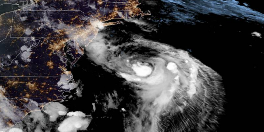
Satellite image of Hurricane Henri.
This hurricane statement was provided by the National Weather Service.
Hurricane Henri Local Statement Advisory Number 24
533 PM EDT Sat Aug 21 2021
This product covers Southeast New York, Northeast New Jersey, and Southern Connecticut
**HURRICANE CONDITIONS EXPECTED ACROSS PORTIONS OF EASTERN LONG
ISLAND AND SOUTHERN CONNECTICUT SUNDAY**
NEW INFORMATION
—————
* CHANGES TO WATCHES AND WARNINGS:
– None
* CURRENT WATCHES AND WARNINGS:
– A Storm Surge Warning and Tropical Storm Warning are in effect
for Bronx, Northern Nassau, Northern Queens, Southern
Fairfield, and Southern Westchester
* STORM INFORMATION:
– About 340 miles south-southeast of New York City NY or about
330 miles south of Montauk Point NY
– 36.3N 71.4W
– Storm Intensity 75 mph
– Movement North-northeast or 20 degrees at 18 mph
SITUATION OVERVIEW
——————
Henri remains a Category 1 hurricane and is currently 330 miles
south of Montauk Point. Henri will likely make landfall near
hurricane strength across the east end of Long Island early Sunday
afternoon, and then track into southern New England late Sunday into
Monday as it weakens.
The main threats from Henri continue to be potentially life-
threatening storm surge, heavy rain capable of producing flash
flooding, tropical storm or hurricane force winds along the south
shore of Long Island and across southern Connecticut. There will
also be associated marine and coastal hazards, including very rough
seas and dangerous rip currents.
Severe beach erosion is possible for coastal areas of Long Island
Sound and portions of Suffolk County, including the Twin Forks
region.
A widespread rainfall of 3 to 6 inches is forecast in the path of
Henri with localized higher amounts possible late tonight through
Monday. The highest amounts are forecast to be across Long Island
and much of southern Connecticut and may occur along and west of the
center of Henri. This will present a likelihood for areas of flash
flooding.
Dangerous marine conditions are likely on the ocean waters south of
Long Island, as well as on Long Island Sound, and the south shore
and eastern bays of Long Island. Dangerous rip currents and high surf
are expected along the ocean beaches of Long Island.
POTENTIAL IMPACTS
—————–
* WIND:
Protect against life-threatening wind having possible extensive
impacts across across eastern Long Island and southern Connecticut.
Potential impacts in this area include:
– Considerable roof damage to sturdy buildings, with some having
window, door, and garage door failures leading to structural
damage. Mobile homes severely damaged, with some destroyed.
Damage accentuated by airborne projectiles. Locations may be
uninhabitable for weeks.
– Many large trees snapped or uprooted along with fences and
roadway signs blown over.
– Some roads impassable from large debris, and more within urban
or heavily wooded places. Several bridges, causeways, and
access routes impassable.
– Large areas with power and communications outages.
Also, protect against dangerous winds having possible significant impacts
across the New York City metro area, portions of the Lower Hudson
Valley, and portions of northeastern New Jersey.
* SURGE:
Protect against life-threatening surge having possible significant
impacts across all coastal areas of Long Island Sound, and much of
the Great South Bay and southeast coast of Long Island. Potential
impacts in this area include:
– Areas of inundation with storm surge flooding accentuated by
waves. Damage to several buildings, mainly near the coast.
– Sections of near shore escape routes and secondary roads become
weakened or washed out, especially in usually vulnerable low
spots. Flood control systems and barriers may become stressed.
– Major beach erosion with heavy surf breaching dunes. Very
dangerous surf and rip currents.
– Moderate damage to marinas, docks, boardwalks, and piers.
Several small craft broken away from moorings, especially in
unprotected anchorages.
Also, protect against locally hazardous surge having possible limited
impacts across Jamaica Bay, and New York Harbor.
* FLOODING RAIN:
Protect against life-threatening rainfall flooding having possible
extensive impacts across Southeast New York, Northeast New Jersey,
and Southern Connecticut. Potential impacts include:
– Major rainfall flooding may prompt many evacuations and rescues.
– Rivers and streams may rapidly overflow their banks in multiple
places. Small streams, creeks, canals, and ditches may become
dangerous rivers. Flood control systems and barriers may become
stressed.
– In hilly terrain, destructive runoff may run quickly down
valleys, and increase susceptibility to rockslides and
mudslides.
– Flood waters can enter many structures within multiple
communities, some structures becoming uninhabitable or washed
away. Many places where flood waters may cover escape routes.
Streets and parking lots become rivers of moving water with
underpasses submerged. Driving conditions become dangerous.
Many road and bridge closures with some weakened or washed out.
* TORNADOES:
Protect against a tornado event having possible limited impacts
across eastern Long Island and southeast Connecticut. Potential
impacts include:
– The occurrence of isolated tornadoes can hinder the execution
of emergency plans during tropical events.
– A few places may experience tornado damage, along with power
and communications disruptions.
– Locations could realize roofs peeled off buildings, chimneys
toppled, mobile homes pushed off foundations or overturned,
large tree tops and branches snapped off, shallow rooted trees
knocked over, moving vehicles blown off roads, and small boats
pulled from moorings.
Elsewhere across Southeast New York, Northeast New Jersey, and
Southern Connecticut, little to no impact is anticipated.
PRECAUTIONARY/PREPAREDNESS ACTIONS
———————————-
* EVACUATIONS:
Listen to local official for recommended preparedness actions,
including possible evacuation. If ordered to evacuate, do so
immediately.
For those not under evacuation orders, assess the risk from wind,
falling trees, and flooding at your location. If you decide to move,
relocate to a safer location nearby. If you do not relocate, help
keep roadways open for those under evacuation orders.
* OTHER PREPAREDNESS INFORMATION:
Now is the time to complete all preparations to protect life and
property in accordance with your emergency plan. Make sure you are in
a safe location before the onset of strong winds or possible flooding.
If you are relocating to safe shelter, leave as early as possible.
Allow extra time to reach your destination. Many roads and bridges
may be closed once strong winds arrive. Check the latest weather
forecast before departing and drive with caution.
Failure to adequately shelter may result in serious injury or loss of
life. Always heed the advice of local officials and comply with any
orders that are issued. Remember that during the storm 9 1 1
Emergency Services may not be able to immediately respond if
conditions are unsafe. This should be a big factor in your decision
making.
Storm surge is the leading killer associated with tropical storms and
hurricanes! Make sure you are in a safe area away from the surge
zone. Even if you are not in a surge prone area, you could find
yourself cut off by flood waters during and after the storm. Heed
evacuation orders issued by local authorities.
Closely monitor http://weather.gov, NOAA Weather radio or local news
outlets for official storm information. Be ready to adapt to possible
changes to the forecast. Ensure you have multiple ways to receive
weather warnings.
* ADDITIONAL SOURCES OF INFORMATION:
– For information on appropriate preparations see http://ready.gov
– For information on creating an emergency plan see
http://getagameplan.org
– For additional disaster preparedness information see
http://redcross.org
Editor’s note: This announcement was provided by the Village of Pelham.
Hurricane Henri is expected to strengthen into a Category 1 hurricane and potentially have impacts on southern Westchester County Sunday morning into Monday. Depending on the storm’s trajectory, sustained winds of 50-60 mph are anticipated, with gusts up to 70-80 mph. Should the storm track further west, conditions may worsen. Heavy rains in the range of two to five inches are also likely.
These conditions will likely result in wind damage, including the potential for falling trees and limbs, as well as drainage and flooding conditions. The Pelham community is encouraged to prepare now for potential impacts from Hurricane Henri, likely to occur Sunday morning into Monday.
Call 911 if you experience an emergency. Cell phone users are advised that contacting the Pelham Police Department directly at (914) 728-2000 to avoid a call transfer delay from 911.
To report a power outage, please call ConEd at 1-800-752-6633 or online at www.coned.com. Concerning the potential for downed trees, wires, and other hazards, please adhere to the following:
1. DO NOT touch a fallen power line or any other electrical equipment. Keep children and pets away from all fallen wires. Report downed wires to 911 or the Pelham Police Department using 914-738-2000, and to CONED at 1-800-75-CONED (1-800-752-6633).
2. DO NOT touch or try to fix any power lines, electrical equipment, or wires on your own. If you notice a problem, call ConEd at 1-800-752-6633.
3. DO NOT relocate or remove any caution tape or barricades placed by emergency workers, as they are to protect you and others from dangerous conditions.
4. DO NOT walk in standing water or attempt to drive through floodwaters.
5. If a power line falls on a car or vehicle you’re in, don’t get out and don’t touch anything outside of the vehicle. The vehicle’s rubber tires will provide insulation and protect you until help arrives. Wait for police, fire, or other emergency service workers.
Preparations should include:
* Be aware of the risk for downed trees/branches, which may be mingled with live electric wires.
* Securing any outdoor furniture or others items from heavy winds.
* Check the operating status for any backup generator you may need.
* Charging all electronics.
* Consider avoiding travel on Sunday.
Village staff is coordinating internally and with both County officials and ConEd to discuss the latest updates to their system preparedness activities. ConEd has already requested and received a commitment for 650 support personnel and has requested another 700.